Join us as we set out to uncover the mesmerizing charm of Ragged Point’s coastal panorama, tread the scenic path of Cruikshank Trail’s inclines, and delve into the captivating landscapes of Point Lobos State Natural Reserve.
Ragged Point
Following our peaceful night in Cambria, we eagerly resumed our journey along the Pacific Coast Highway. Our next destination was Ragged Point, a mere 30-minute drive from Cambria. However, as we arrived in the morning, a thick blanket of fog obscured the landscape. It seemed as if we had stumbled into a mysterious realm, walking through a magical forest shrouded in clouds. The silver lining was that the absence of crowds lent an almost ethereal quality to the experience.
Speaking of fog, it’s a familiar companion along the Pacific Coast during the summer months. To truly savor the breathtaking vistas from spots like Ragged Point, timing is crucial. The period between noon and 4 PM typically offers the clearest views. By around 2 PM, the fog often dissipates, unveiling the scenery in all its glory. Like clockwork, the mist tends to return around 5 PM; however, the dance of the fog itself becomes a spectacle to behold.


Cruikshank Trail
Continuing our journey from Ragged Point, we ventured a bit further north to explore the Cruikshank Trail. Keep an eye out for the somewhat inconspicuous trailhead – as you approach, reduce your speed. You’ll notice cars parked along the side of the Pacific Coast Highway – feel free to do the same.
This dog-friendly dirt trail gradually ascends the mountainside, demanding proper hiking shoes with reliable traction. Despite the fog still enveloping the surroundings, the experience was far from disappointing. While the anticipated ocean view remained veiled, the fog painted a unique beauty, creating an illusion of walking above the clouds. We trekked for roughly 30 minutes until we reached a point marked by a Los Padres National Forest sign. There, we opted to retrace our steps. For those seeking better visibility, afternoon visits are advised, even if it means encountering warmer temperatures.


Jade Cove & McWay Falls
Here’s where a twist came into our itinerary… Massive mudslides unexpectedly blocked off the Pacific Coast Highway ahead. Our original plan was to continue our journey northward along the coastal route all the way to Monterey. However, the mudslide situation required a detour. We found ourselves retracing our route to Cambria and then charting a new course via Highway 101 to reach Monterey.
Assuming you don’t face the unfortunate road closures we encountered, a noteworthy suggestion is Jade Cove. I’ve heard it’s a stunning spot to visit.
A bit further north, there’s McWay Falls. This short trail leads to a coastal waterfall. Regrettably, our four-legged companions aren’t allowed, but it might be an appealing stop if you’re traveling with fellow human adventurers who can pup-sit while you embark on a brief hike to admire the falls.
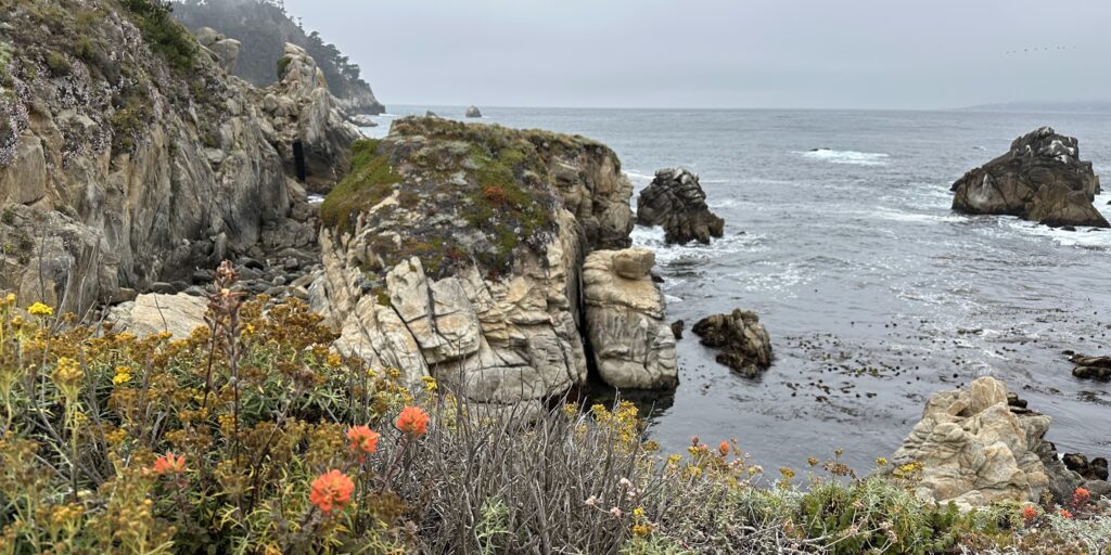
Point Lobos State Natural Reserve
Due to an unexpected road closure along the Pacific Coast Highway between San Simeon and Big Sur, we found ourselves in Monterey earlier than planned, having taken the detour via Highway 101. With Toby understandably weary from the drive, I opted to let him rest while I explored the Point Lobos State Natural Reserve. This exquisite reserve boasts accessible trails along Point Lobos. Regrettably, for safety reasons, our canine friends aren’t permitted due to the prevalence of poison oak – a concern for humans as well.
A $10 fee provides entry to support California Parks. You’ll find various parking spots that offer access to nearby trails. The pathways offer a relaxing stroll or a more extensive hike around the entire Point Lobos if you’re feeling adventurous. Either way, this spot offers a perfect couple of hours for exploration. If you’re seeking some solitude or simply wish to pamper your pup with some much-needed rest, this reserve is an excellent choice.


